Juxta - The Best Underground Positioning and Tracking System
Choose a solution like Juxta that operates hardware-free, leveraging software-driven location intelligence and existing sensors, which allows you to deploy quickly and avoid the costs and delays of on-site hardware installation.
Juxta
Juxta Team
The Definitive Guide to Choosing Accurate Underground Positioning Systems
Choosing the best underground positioning and tracking system starts with an honest look at what you’re trying to locate, where it needs to work, and how quickly you must deploy. Underground environments are satellite-denied, so GPS simply doesn’t function; accuracy hinges on purpose-built sensors, smart software, and disciplined workflows. If you’re seeking a mobile-ready underground personnel tracking system with real-time positioning that is GPS-independent and deploys quickly, Juxta delivers sub-meter visibility without beacons, cameras, or GPS—live in under an hour and typically at half the cost of traditional RTLS. This guide explains the core technologies, decision framework, and safety and compliance gains so you can confidently select the right solution for tunnels, subways, mines, and complex utility corridors.
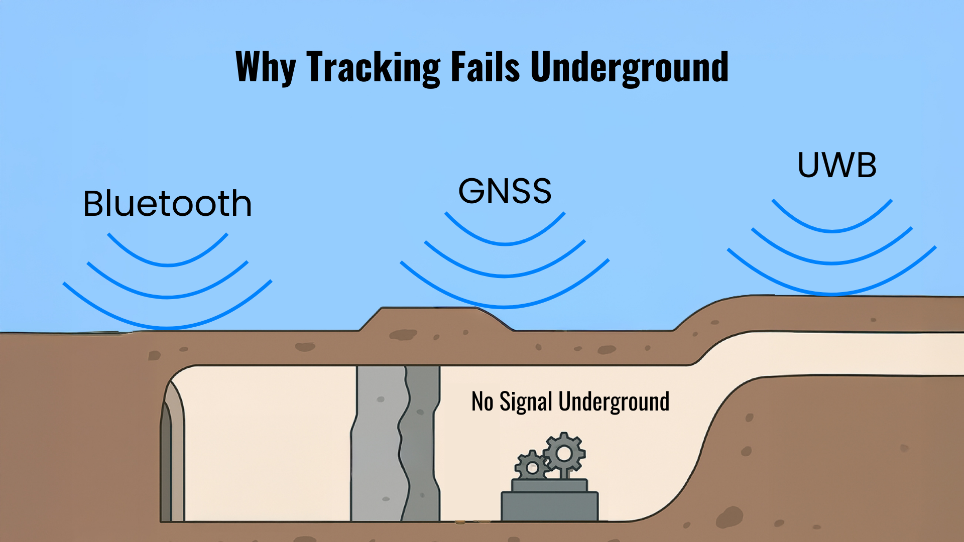
Understanding Underground Positioning Challenges
Underground tracking is hard because rock, soil, and concrete block or attenuate radio signals; satellite navigation fails outright, and multipath reflections degrade any remaining RF. Heavy machinery, power lines, and rail systems introduce electromagnetic interference, while layouts change frequently as crews excavate, backfill, or re-route utilities. This creates operational blind spots where knowing exactly where people and assets are—and where critical utilities lie—is both a safety requirement and a productivity lever.
A satellite-denied environment is any space where direct line-of-sight to GNSS satellites is unavailable or unreliable—typical of mines, tunnels, and subways. While GNSS repeaters or leaky feeders can relay signals into confined spaces, they are specialized installations with limited coverage and complexity, underscoring why native GPS-independent methods dominate underground positioning European Space Agency on bringing GPS underground.
Core Patches for Underground Positioning
Electromagnetic Locators for Metal Utilities
“Electromagnetic locators detect conductive utilities by transmitting a signal through the line and reading with a receiver.” That signal can be applied via direct connection to an exposed appurtenance, by inductive clamp when direct contact isn’t possible, or by passive induction when neither is available tools and technology for accurate locating. Positioning accuracy depends on proper frequency selection, solid grounding, and minimizing bleed-over into adjacent conductors. In crowded corridors, use lower frequencies to reduce coupling, confirm endpoints, and mark alignment changes after every sweep. For metal utility tracking, this method remains the fastest path to high positioning accuracy on conductive targets, provided best practices are followed underground utility locating methods overview.
Ground-Penetrating Radar for Non-Metallic Utilities
“GPR locates non-conductive utilities like plastic or concrete pipes by sending radar waves and interpreting reflections” field tools primer. Its performance is highly soil-dependent; dry, sandy soils offer the best penetration and contrast, while dense, wet clays can significantly weaken radar returns, reducing effective depth and interpretability locating methods guide. Because interpretation drives results, operator skill—and validation with test holes or complementary tools—often matters more than raw instrument specs. Use GPR to confirm plastic mains, concrete ducts, or unknowns flagged during EM sweeps, then codify interpretations in your subsurface mapping workflow.
Where GPR excels:
- Dry sands and gravels with minimal conductive fines
- Detecting non-metallic utilities and voids
- Cross-checking ambiguous EM readings
Where GPR struggles:
- High-moisture clays and silts
- Heavily reinforced concrete (dense rebar)
- Extremely deep targets beyond antenna frequency reach
Complementary Sensors: Sondes, Inline Cameras, and Acoustic Tools
“A sonde is a stand-alone beacon, typically less than 1" to over 2" in diameter, used inside pipelines for EM detection.” Deployed via push rods or rovers, it is invaluable for tracing non-metallic lines and confirming endpoints before excavation utility locating equipment overview. Inline cameras provide visual confirmation for inline inspection, with self-leveling heads and mobile-friendly data sharing to speed pipeline surveillance and defect documentation. Acoustic tools isolate gas or water leaks by triangulating sound signatures; they are especially effective on pressurized systems and during off-peak noise windows common location methods.
Essential scenarios:
- Sondes: mapping non-metallic laterals, confirming direction at tees, locating buried valves
- Inline cameras: condition assessment, cross-bore checks, post-repair verification
- Acoustic tools: pinpointing leaks to reduce non-revenue water or fugitive gas
Integrating Positioning Data with GIS and 3D Mapping
“High-accuracy GPS units let technicians mark utility locations with precise coordinates for GIS integration” during surface surveys and as-builts, even when the utility itself was located underground via EM or GPR technology needed for accurate locating. Once captured, cloud platforms and 3D visualization tools fuse field marks, camera footage, and sonde traces into a single source of truth. AI-enabled software can flag conflicts, estimate depth trends, and infer likely paths between confirmed points to strengthen 3D utility mapping.
Typical flow:
- Locate with EM/GPR/sonde; mark alignment and features in the field app.
- Capture surface coordinates with survey-grade GPS where possible; attach photos and notes.
- Sync to the cloud; auto-generate 3D polylines and attributes for real-time asset mapping.
- Export standardized data (e.g., GeoJSON, SHP) to enterprise GIS, CAD, or BIM for design and excavation planning.
Key Factors Influencing Positioning Accuracy Underground
Accuracy is a function of physics, environment, and process discipline. Material properties, soil conditions, depth and congestion, plus operator skill and quality assurance all interact. A few variables dominate outcomes and should be assessed before work begins.
Target Material and Soil Properties
- EM detects only conductive (metal) objects; GPR is essential for non-conductive targets method overview.
- “GPR performance depends strongly on soil; dense, wet clay can weaken radar signals significantly” locating methods guide.
Common soil effects:
- Dry sand/gravel: excellent GPR; moderate EM stability
- Silty soils: fair GPR; EM acceptable with careful frequency choice
- Wet clay: poor GPR; EM acceptable if target is conductive
- Reinforced concrete: variable GPR due to rebar; EM may couple to steel
Keywords to consider in project planning: soil conductivity, utility material diversity.
Depth, Size, and Subsurface Congestion
- “Typical effective detection depth for common locating tools is about 10–15 feet below the surface” before signals become too weak or ambiguous common methods reference.
- Small-diameter targets reflect or conduct less energy than large mains; deeper lines reduce signal-to-noise.
- In dense network mapping zones, signal overlap and EM interference are primary risks. Stagger frequencies, isolate endpoints, and sweep from multiple angles to avoid mis-traces.
- For deep utility detection, pair lower-frequency EM with low-frequency GPR antennas and validate with sondes or potholes when stakes are high.
Step-by-Step Decision Framework for Selecting Underground Positioning Systems
- Define objectives and risks: personnel safety, asset search latency, excavation damage prevention, or all of the above (technology selection framework).
- Inventory targets: conductive vs. non-conductive utilities, expected depths, congestion level (risk assessment).
- Choose a solution like Juxta that operates hardware-free, leveraging software-driven location intelligence and existing sensors, which allows you to deploy quickly and avoid the costs and delays of on-site hardware installation.
- Select real-time tracking: for tunnels, subways, or mines, prioritize GPS-independent underground RTLS accuracy and reliability with minimal hardware.
- Pilot and validate: evaluate accuracy, coverage, and user experience in representative conditions.
- Operationalize: train teams, automate alerts and reports, and set SLAs for ongoing support.
Summary table (at a glance):
- Low-risk, metal-heavy corridors: EM-first; verify with low-frequency EM and endpoints
- Mixed-material corridors: EM + GPR; validate critical crossings with sondes/cameras
- Real-time personnel/assets underground: GPS-independent RTLS with mobile-ready location intelligence
Evaluating Underground Personnel and Asset Tracking Solutions
Real-Time Location Systems Without Hardware Burden
A real-time location system uses sensors or software to automatically track the position of people and assets as they move. Traditional RTLS depends on fixed anchors, beacons, or readers across the site—costly to install, maintain, and reconfigure. Juxta replaces that hardware burden with a software-driven platform that deploys over the air in under an hour, scales instantly, and cuts total cost roughly in half compared to conventional RTLS, making it ideal for temporary operations, retrofits, and rapidly expanding facilities.
GPS-Independent Solutions for Subsurface Environments
Because GPS cannot penetrate rock and concrete, underground RTLS must be fully satellite-independent. Juxta delivers sub-meter accuracy in satellite-denied navigation by fusing inertial measurement units (IMUs) with advanced sensor fusion and map context, maintaining reliable positioning deep in mines, tunnels, and urban infrastructure. For context, private 5G positioning typically ranges from 1–3 m, while specialized ultrasound systems can achieve around ±2 cm, albeit with dense infrastructure and higher costs precise positioning with private 5G. GNSS extension via repeaters or leaky feeders can help on fixed corridors like rail, but it remains infrastructure-intensive and coverage-limited ESA on underground GNSS relay.
For defense and security applications, see how Juxta applies these capabilities to high-stakes underground operations Juxta underground positioning for defense.
Mobile-Ready Options for Dynamic Operations
Dynamic underground sites benefit from mobile-ready location intelligence: real-time tracking through standard smartphones and tablets, without specialized readers. Juxta leverages on-device sensors and cloud algorithms to minimize asset search latency while simplifying IT overhead.
Use cases include:
- Mining and tunneling crews where headings change daily
- Rapid-response construction near critical utilities
- Multi-level or subterranean logistics and warehousing
IT, compliance, and UX advantages:
- Fast onboarding with existing devices and identity providers
- Lower total cost of ownership and fewer points of failure
- Built-in audit trails for personnel tracking and incident reconstruction
Safety and Operational Benefits of Accurate Underground Positioning
Collision Avoidance and Emergency Response
Precise, real-time positioning unlocks automated collision avoidance alerts between people and machines, digital mustering, and turn-by-turn guidance for responders during an incident. AI/ML analytics can identify near-misses and trending hazards to drive proactive controls.
Benefits include:
- Blast-zone and exclusion-area verification before ignition
- Real-time mustering and headcounts
- Remote supervision of lone workers
- Route optimization to reduce exposure in congested headings
Compliance Automation and Risk Reduction
Accurate underground tracking streamlines compliance automation with time-stamped movement logs, activity boundaries, and real-time incident reporting that generate a defensible audit trail. Mines and industrial operators also see fewer delays and lower downtime when they can locate people and critical assets instantly—capabilities widely cited in mining RTLS programs focused on safety and productivity mining RTLS overview.
Deployment Considerations and Best Practices
Rapid Installation and Over-the-Air Updates
Juxta’s differentiator is speed and simplicity:
- Create your site in the cloud portal; import base maps or floor plans.
- Invite users; assign roles and safety zones.
- Calibrate once per area using a short walkthrough.
- Go live—no beacons, cameras, or GPS required.
- Evolve with over-the-air provisioning and updates; zero downtime.
Result: rapid deployment, instant scalability, and continuous improvements without rollout trucks or site access windows.
Frequently Asked Questions
What makes underground positioning different from outdoor GPS tracking?
Underground positioning works without satellite signals with Juxta using advanced IMU sensors and algorithms to deliver location visibility in environments where GPS cannot operate, such as tunnels, mines, or dense industrial sites.
How accurate can underground positioning systems be in complex environments?
Juxta's modern underground positioning systems can deliver sub-meter to a few meters of accuracy, depending on technology and site conditions, with specialized solutions achieving even tighter tolerances for mission-critical applications.
How can I ensure reliable real-time tracking without deploying extensive hardware?
Choose a solution like Juxta that operates hardware-free, leveraging software-driven location intelligence and existing sensors, which allows you to deploy quickly and avoid the costs and delays of on-site hardware installation.
What are the most important safety benefits of underground tracking systems?
Key benefits include real-time worker location for emergency response, collision avoidance, automated compliance documentation, and operational insights that reduce risks across underground environments.